At the moment (March – Nov 2015), My husband and I are travelling by bike from Greece to China.
We have another blog telling this tale, so please visit http://www.towardtherisingsun.wordpress.com to follow.

At the moment (March – Nov 2015), My husband and I are travelling by bike from Greece to China.
We have another blog telling this tale, so please visit http://www.towardtherisingsun.wordpress.com to follow.
Leaving my castle in the sky – the ethereal, cool, meandering trails through tea plantations in the Sri Lankan Highlands, I decided to head down and East, to the surfer hangout of Aragum Bay, and then beach hop my way around the Southern Coast back to Colombo.

My tree hugging Curly Monkey
Sri Lanka is about the size of Otago and Southland, with a population of 20 million. It seemed to me to be a bountiful paradise. Fresh produce stalls dot the roadsides in a rainbow kaleidoscope of color. I’m sure there is an element of poverty, but in the areas I visited, by and large people seemed relaxed and to have a pretty good standard of living. The gap between the rich and poor in rural areas didn’t seem too vast, especially compared with the rude shock of northern India to come. Due to the high population, I was never far from anyone, houses, or roadside stalls. Except through the national parks.

Bountiful Paradise
Apparently 50 people die each year by Elephants. AND Adrenalin is a good cure for Sri Lankan coconut rum hangovers.
I had happily coasted down from the highlands towards the East Coast. I got quite a shock as I left the last few villages which were fortified with 10ft high barbed wire fences, and rolled through an eerie National Park. There were ‘Caution, Elephant’ signs, but all I saw was the occasional steaming mountain of elephant shit in the middle of the road. Eek, I understand cows, dogs, earthquakes, avalanches and even penguins, but not elephants.
From my Diary: Anyway my current problem is that Aragum Bay is a one way in, one way out kinda place, so today is devoted to finding out:
1) How dangerous are wild elephants?
2) How easy is it to get me and my bike on the back of a truck?
After considerable talk with the locals who mostly were adamant that I would see Elephants (as they were trying to sell me a tour), I was assured that Elephants are not out in the morning. So I decided to ride – AND SAW 2 WILD ELEPHANTS about 50m from the road! They weren’t bothered by me at all, just kept munching and spraying themselves! My legs were a blur, and my hangover momentarily cured!

Eek
The area around Aragum Bay had been heavily affected by the civil war, and only recently had tourists started to trickle back in – primarily eclectic surfers hunting for waves and cheap living. The East Coast had also been hit hard by the Boxing Day Tsunami. It seemed that the harder the civil war hit, the slower the recovery after the Tsunami, and there was a considerable legacy of abandoned flattened houses. Disaster recovery is so complex (speaking from post quake Christchurch), but add Civil war to the mix and well……

Tsunami Legacy
Beyond my wild elephant run-ins (there was more than one), life was real tough. I beach hoped my way around the coast back to Colombo. I’d cycle in the morning, and swim in the afternoon. I’ve never been to Europe, but spending a few days in Galle which was my slice of Europe. Galle is a beautiful 16th century Portuguese fort city, full of expats, art, coffee and dotted with Buddhist temples, lighthouses and mosques. I’m sure I could have become the muse of some expat artist and sipped wine in a hammock under palm fronds for the rest of my days. Ahhh too much time in the imagination of my brain while peddling a bicycle…

Galle: Buddhism mixed with a slice of the Mediterranean

Tough Life. Lying at the southern tip of Sri Lanka, gazing out to Antarctica.
So I bought a Surly Long Haul Trucker. And rode it from Wanaka to Hokitika. It was a practice run, a wee test. Could I cope in my own company. Turns out, I talked a lot to my bike, her name is Curly Monkey and we are pretty good mates.
The west coast was one thing – Sri Lanka was another.

Curly Monkey meets my Sri Lankan Grandmother Brenda
I had a woper meltdown on day two. Digging back to the rawness of that day. I was in the safety of a lackluster backpackers, it was hot, so so hot. The beach was ok, but I was uninspired to swim due to my new awareness of being a loan blond in Asia. I was exhausted, alone and didn’t quite know what to do next. Six weeks without a plan, just me and a bike, and it was just too hot. I rang my boyfriend at the time and balled my eyes out “Who’s stupid idea was this? What the hell am I doing in Sri Lanka, by myself with a bike?”. He was settling into an Antarctic winter and the temperature was dropping. Every time it dipped below -42°C the crew would stop and have a Vodka shot of 42 Below. There was no way on or off the icy continent until October. It was April.
Getting to this meltdown, I’d had two nights of very little sleep in transit. I eventually arrived into Colombo airport, frazzled and attempted to find a quiet corner. A head waggling male audience immerged out of nowhere to watch the spectacle. Pretending it was all perfectly normal, I reconstructed my bike. My chain broke. I fixed it. Realizing I had threaded it backwards through my derailer. I rebroke it, rethreaded it and refixed it. Grease everywhere. I asked a few directions to Negombo beach, 15km away and tentatively rolled out the gate. I suppose it was like the comedown from any drug. In my case the drugs of Adrenaline, and Necessity. Once in the safety of the backpackers it all came tumbling down.

View for a meltdown
The only way from this point was up, both emotionally and geographically. It was too hot and too stressful to stay “down”. I wound a path through inland paddy fields, and headed up. I cycled off the main roads and meandering through the Ceylon tea plantations, rubbing shoulders with Mr Dilmer and the like. The greens of Sri Lanka are psychedelic. My eyes couldn’t absorb enough – it was a more vibrant and saturated concoction of green than Id ever seen before.

Greener than green – Tea, Mr Dilmer?
From my Diary: Well, I’m about as far away from Antarctica as you can get. Its hot and humid, and I can just about see the insects multiplying and the jungle spreading!
Eventually after a couple of weeks in the central highlands of Sri Lanka I joined thousands of pilgrims to climb and watch the sunrise from the top of Sri Pada, a 2200m, Matterhorn-esk peak. The experience was an assault on the senses. The air smelt a mix of incense, citronella, sweat, rubbish and sewage. Loud speakers blared, women sang throaty mantras, kids cried and young me yelled their insistent “Hello, where are you going?” at me, of which I replied “To the moon”. Clearly we were all walking up the only mountain track that wound its way steeper and narrower, until a complete human bottleneck brought us almost to the moon, to the temple on the peak. We all elbowed for a sunrise viewpoint and then the Buddhists, Hindus, Muslims, and Christians began to worship. Sri Pada means sacred footprint, named after a large indentation resembling a footprint near the summit. For Buddhists, this is the footprint of Buddha. Incidentally the Hindus believe this to be the footprint of Shiva, and the Muslims and Christians, Adam. Fascinating that everyone decided that this one indentation is sacred, but regardless it was an impressive display of religions peacefully sharing a sacred site.
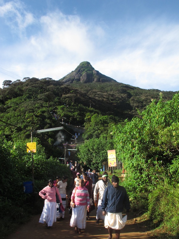
Sri Pada, the Temple in the Sky

Human bottle neck heading back down at first light
In February 2011 I finished my first season on The Ice, my dream had come true to work at Scott Base, Antarctica. I was in need of escaping anything remotely institutional and needed to remedy my Antarctic tan. I was cashed up and free.
I’m not entirely sure how I came up with my plan to cycle through Sri Lanka and India alone for 4 months. I knew my travel either needed to be a journey of sorts, or it required a robust purpose. If not, I was quickly going to become bored and disillusioned. When I spun the globe, my finger miraculously always landed on India and I would drift off into dreams filled with chaotic color. I was tossing up ideas about finding aid work in Asia, when I got highly sidetracked by a book a friend loaned me, called Himalaya by Bike.

Dreams of my imagination
So that was that.
I knew how impossible it was to organize friends to take such a long amount of time off work, especially to go ride a bicycle around Asia, so I figured I’d have to be prepared to go alone. If people came with me, well that would be a bonus. And well, Laura Stone did it (the author of Himalaya by Bike), so why couldn’t I? I must admit, I was pretty stoked when my mate Steph said she would come along for the second half of the trip.

1940’s England? No, modern India.
Since returning I have discovered Dervla Murphy . She is hands down, my hero. She is a complete legend. An understated powerhouse of awesomeness! Read Full Tilt – Ireland to India with a bicycle. Dervla, 1963, alone, with a revolver….. Read it!

Wicked – Dervla Murphy (in 1994)
Anyway these blog entries are written post event. I’m trying to improve my writing skills, and the entire story will be slowly drip fed here. There is no particular purpose, but if you read them, I hope you enjoy them.

In love with India
Definition:
Jolly: adjective. a field trip where work is done, but the enjoyment of being in the area outweighs any hardships.
A hard days travel through remote and unsympathetic country, wintery conditions, repetitive work, long hours, must be good at digging holes and not mind being in a small team likely to be made up of hairy smelly men. Voluntary. Will involve views to die for and heli-skiing!
For me it was a no brainer, for sure I would drive to Mt Cook to be part of the team of scientists laying siege to the Jollie Catchment in the annual snow survey. The National Institute of Water and Atmosphere (NIWA), over 4 consecutive years has undertaken the Jollie Snow Experiment (J-SEx), collecting hundreds of snow depth and density samples over a single day at the time of maximum snow storage.

With the boys, on the ridge. Ready for a Jolly Jollie. Photo by Jason Blair
In hydrological models, snow has traditionally been treated simply as ‘snow’. Anyone who has spent any time in the mountains knows full well that all snow is not created equally. Firstly snow does not layer onto the mountains like Christmas cake icing in perfect uniform thickness. Rather it billows around under the force of the storm, accumulating in some areas and being stripped in others perhaps like trying to ice a head of broccoli while someone holds a hair dryer next to it. Strangely I’ve never tried to do this, but I’m sure you would end up with variable icing cover. Secondly as any skiers will know, some snow is like icing powder, some like porridge and some like sheet ice, all which have very different densities. Therefore from a water storage point of view, snow is variable.
Satellite images that gather snow data for hydrological models have the ability to measure more than just the presence of snow. As the Inuit peoples of the Arctic know, snow is not just white. The Inuit people have many different words for what we simply call snow. Satellite images have the ability to measure more parameters but to ensure accuracy this requires ground truth points. In other words, if I can tell the satellite that the “pixel” I am standing on is x, and the pixel that Fred is standing on is y, and the pixel that Charlie is standing on is z, it can then work out the values for all the pixels between me and the boys. This is called extrapolating the data, and is a powerful remote sensing tool for obtaining data for large areas that could never be covered by foot. In fact, remote sensing has changed the way people do modern earth science.

No description required. Photo by Jason Blair
The Jollie catchment is a contributor to Lake Pukaki, one of New Zealand’s major hydroelectricity dams, and it is a relatively small and simple catchment with a water flow gauge on the stream. There is good satellite coverage but little was understood about snow depth and density and the environmental drivers of this. In order to understand what the satellite can measure, ground data has to collected, and this is where the siege comes in. One day, and as many people as possible to take as many samples as possible. And the quickest way to get people around the mountains – helicopter to the top, ski to the bottom. Simple.

Helicopter with GPR strapped underneath. Photo by Jason Blair
So in teams of 4 were dropped in by helicopter along the ridges bounding the catchment. We all skied down into the valley, stopping every 100m in elevation to take snow samples. Now don’t get me wrong, a bit of hard labor was done at every 100m, but it was between beautifully carved fresh turns.

Digging. Photo by Jason Blair
We did a bit of digging! At each location we dug a snow pit, either to the base, or until the snow became isothermic (so the pits were all at least 2m deep). Down the snow pit we measured the temperature, the permeability, noted the depth of all the layers, and took snow density measurements every 10cm. While two people were doing this the other two did a snow depth transect, probing the depth of the snow every meter along the contour for 100m.

Snow pack analysis. Photo by Jason Blair
As well as the ground teams, a Ground Penetrating Radar (GPR) was strapped underneath the helicopter. This was able to measure the depth of the snow, and was verified by the ground measurements. The airborne GPR was successfully tested and into the future will be used over ground sampling as a greater area can be covered increasing the spatial resolution for catchment wide sampling for snow storage estimates.

Snow depth probing
Jolly good!
Back in the helicopter, and back into the mountains for another soil sampling siege – I’m just about convinced that I am James Bond. Antarctica New Zealand has provided some impressive helicopter logistics, orchestrated by Barry, the operations scheduler at Scott Base to get us to all the 75 sampling sites. It has been most appreciated.

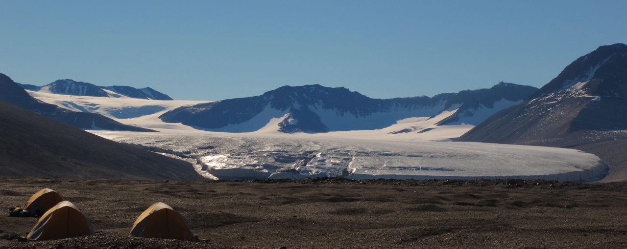
View from the helo – Wilson Piedmont Glacier draining inland into Lake Vida
This time, it was team Blond, not team Bond. And Kristi and I were specifically on an Invertebrate hunt, as we hiked back to base camp over two days.

Kristi, myself and Alia in the base camp tent.
Kristi Bennet is a Masters student from the University of Waikato studying population genetics of springtails in the McMurdo Dry Valleys. Springtails are the largest living terrestrial organism in Antarctica, measuring in at a whooping 1-3mm. The only other visible living invertebrates are Mites. These are the ‘lions and tigers’ of Antarctica, top of the food chain – the megafauna! Springtails are found worldwide and are the words most abundant soil arthropod. They have a long evolutionary history and are one of the first arthropods that show up in the fossil record. There are 3 species found in the Dry Valleys, Antarcticinella monoculata, Neocryptopygus nivicolus and Gompheocephalous hodgsoni. During this expedition Antarcticinella monoculata was found, for the first time since the 1960s. The current hypothesis for their distribution is that they are remnants from Gondwanaland and have survived the once warmer continent becoming a polar ice cap.

Kristi Bennet – Masters student researching Antarctic springtails
Hunting for Springtails and Mites is a fine art. They have very particular places they like to hang out. They are found on the mountain peaks, in areas with some water, where snow naturally accumulates. They like to live under flat black rocks, sheltered from the harsh winds by larger boulders, on north facing slopes, with good school zoning and close to the shops…. For us, it means spending lots of time on our hands and knees turning over rocks. So I am a glaciologist by trade, and until this point the field groups had had very little luck in finding any mites or springtails. It was when I finally turned over a rock to see tiny red mites scuttling across the underside of the rock, that I truly understood the microbiologists passion and yelled at Kristi “oh oh oh, Ive found some mites!!!”.
Next we had to collect the mites. A specially designed aspirator was used. They are sucked up through a tube, and to prevent eating them, they are caught on a filter and fall into a plastic vile. Mites and springtails are also found in the soil samples. To separate them form the soil, in the lab the soil is mixed with a sugar solution and any organic matter, including the mites and springtails floats out. They are then scooped out, preserved in ethanol and taken back to New Zealand for genetic analysis.

Alia and Kristi working with samples in the field lab at base camp
By the end of the field time, the total count of springtails found was approximately 100, and 300 mites were also collected. Needless to say, Kristi was pretty happy with the count, and will be spending time in the lab, studying the genetics of these springtails.
Log book record: “Quiet day, but a bloke called John popped in for a cuppa”
After three big field days with people scampering all over the landscape: climbing peaks, navigating ridges, rock hoping granite and weaving through dolerite boulder fields we were all due a rest day. With the whole team back at Base Camp, we had our ear to the radio awaiting news from the helicopter that Prime Minister John Key was on his way to our camp for a visit.
Camp days consist of a variety of occupations. Coffee is drunk, soil samples are processed, bread is baked, yoga is done, water is collected, scones are baked and the crew generally relaxes and gears up for the next onslaught of sampling across the mountains. With 14 people in the one communal tent, the art of dancing around each other in coordinated chaos is finely tuned.

Base Camp – coordinated chaos!
“K020. K020. This is India Delta Echo. Do you copy?”
“India Delta Echo, this is K020. Go ahead”
“K020 we are flying in over Bull Pass, we will be on the ground in 4 minutes. Over”
“Copy that India Delta Echo. The wind here is 5knots from the west. See you in 4 minutes”
Our radio call sign is K020, and India Delta Echo is the name of the Southern Lakes Helicopters Helicopter. Out of the helicopter climbed Lou Sanson, the CEO of Antarctica New Zealand, followed by Prime Minister John Key and his wife Bronagh for a short visit to camp.

Prime Minister John Key arriving at our field camp
With the help of Professor Craig Cary, the Prime Minister took the first biodiversity sample for the new Antarctic Genetic Archive (AGAr), numbered MDV 0001.

Prime Minister John Key and Professor Craig Cary taking the first soil sample for AGAr – photo: Don Cowan
AGAr, is a tool to link all biodiversity research being conducted in Antarctica, by housing a DNA archive. Once collected, this will enable researchers from all countries to gain access to valuable DNA samples without the necessity of going to the remote locations. This enhances biodiversity research worldwide by making data collection more efficient, and reducing the overall environmental impact on the pristine and fragile Antarctic environment. This continent scale biodiversity archive will be the first of its kind in the world. The archive has the capacity to hold 1 million DNA samples and can be contributed to by any scientists working in Antarctica. Technology now allows scientists to collect, extract and store DNA very efficiently. Once established, the archive will be available to the research community across the world.

nzTABS team with Prime Minister John Key – Photo; Lou Sanson
Then on for a cuppa, and some fresh cinnamon pinwheel scones. I had been perfecting the art of the camp scone – and the Prime Minister seemed to like them.

Hot cinnamon pinwheel scones – they were inhaled by the crew, so cant have been too bad – Photo: Don Cowan
The most obvious thing when we arrived at Sub Camp 2, apart from the delicious smell of dinner, was the array of interesting and alien looking gadgets along the lakeshore. A day spent with Peyman Zawar-Reza and Marwan Katurji, both lecturers at the Centre for Atmospheric Research at the University of Canterbury, and I’ve now got a handle of what they all do.

An array of Atmospheric Research Equipment
But firstly….. the Dry Valleys are dry! Antarctica is the driest continent on earth, which ironically is 98% covered in ice. The Dry Valleys receive around 50mm of precipitation per year at the valley mouths and almost nothing at the head of the valleys. Why? Because of the rain shadow effect from the Transantarctic mountains. Very simplistically the weather in the Dry Valleys is as follows: In the summer under 24hour sun, when there is regionally calm weather, the winds are driven by thermal circulations which causes up valley winds during the day. During the few hours when the low sun casts shadow into the valleys, the temperature drops a few degrees and there is a weak down valley wind. The major weather comes from the outside, in summer low-pressure systems bring strong winds into the valley, and if dense with moisture, snow will fall. In the winter when the circumpolar vortex strengthens, low-pressure systems cause hurricane strength warm foehn winds to funnel down into the valleys. These are the strong winds that pick up sand and blast and erode the rocks causing sculpted ventifacts.
To understand the biocomplexity of the Dry Valleys ecosystems, it is critical to understand the microclimate. Temperature and water are critical for life. I know that I require water and warmth to live in the Dry Valleys, and a few cinnamon scones! So what causes surface temperature to rise above freezing? And what causes precipitation?
Marwan and Peyman are also looking at finer scale climate questions. They are interested in the atmosphere very close to the surface – below 500m. Specifically wind interaction with topography, turbulence, waves, and the forcings behind them. The Dry Valleys represent a simplified system with no vegetation, which is ideal for theory and hypothesis testing.
They have some serious gadgets, 700 kilos of gadgets in fact. There is the SODAR (sound detection and ranging), and a RASS (radio acoustic sounding system), a surface automatic weather station, and a kite. The SODAR and RASS instruments measure wind speed, wind direction and temperature in a vertical profile from the ground up to 500m every 10 minutes.

RASS

SODAR Receiver
But the most fun, was flying the kite. A beautiful bright yellow and red 4m kite is attached to a hand winch and flown with instruments attached to validating the temperature profiles taken by the RASS up to 300m. It is labour intensive but necessary for checking the remote sensing gear. Kites work better than weather balloons in windy environments, such as the Dry Valleys.

Flying to kite to validate the RASS and SODAR
All in all, after a hospitable night at sub camp 2, a jolly good day eating curry, flying kites and playing with gadgets! Back to Main Camp tomorrow.
Destination: Olympus Range! It sounds so grand. And oh how it was. As there were helicopter movements in the area, we were dropped at the top of the Olympus Range at sampling routes to follow down to the Valley floor. It’s amazing how 5 minutes by helicopter can take days to cover on foot. Steve Pointing, a Professor of Ecosystem Ecology from the Earth and Ocean Sciences Research Institute at AUT and I were dropped off by helo at 1700m elevation on the crest of the mountains. A vista of naked mountains and perfectly sculpted glaciers were matched with distant icebergs in the frozen white Ross Sea. All under a calm and cloudless blue sky. One of the difficult things to judge in Antarctica is the distance. The atmosphere is so crisp and the scenery so big, that without trees for scale judging distance is almost impossible. More than likely if something looks 1km away, it is probably 10km away. But with a trusty GPS, you can tell just how close or distant it is to the next sampling location.

Steve and I on the top of the Olympus Range, ready to start hiking.

Lake Vida and the Olympus Range
We trotted our way down through ancient mountain landscapes, most likely where know one had ever trodden before. As we travelled, we crossed an assortment of distinct and beautiful landscapes: weathered slabs of granite bedrock, desert pavements of dolerite, sandy polygons, and dreaded chunky boulder fields.

Granite boulders dripping like wax, carved by the power of sand blasting

An amazing view and a long way to go.
So how do we take a sample? Well, firstly we hiked by GPS to the specific location – a point chosen to be an indicator of a specific geology, aspect, slope, elevation and temperature. The first sampling task requires doing just what you feel like after hiking kilometers of rough terrain. Lie down and spend 10 minutes hunting beneath rocks for springtails and mites, the only VISIBLE invertebrates that live in Antarctica, which are mere millimeters in size. Then soil samples are taken which are analysed in the lab. Lastly a 10m transect is laid out and any lichens, mosses or cyanobacteria that are seen are noted down. In some locations there is a lot of life to be found. Where we were, we saw not one springtail, mite, moss, lichen, or any sign of life. I can sympathise with Scott – these valleys do appear to be void of life. However what will be seen in the lab will show another story.

Catarina soil sampling
As we hiked and sampled, our packs grew increasingly heavy with samples of soil. Our packs lost weight as we drank our water, but gained weight with bottles of pee. In Antarctica nothing in left in the field, including human waste. As a woman, peeing into a bottle is something of an art! With the aid of a FUD, a female urinary director, hey presto, peeing is not a problem. Go on, Google it, I’m not going into any more detail here…..
10 hours of walking later, we arrived into sub camp 2, otherwise known as Camp Curry, to the warm welcome of Marwan and Peyman and a big pot of delicious hot steaming curry. Situated on the side of Lake Vida in the center of a perfect polygon, the site of 3 yellow tents and an array of atmospheric gadgets was a welcome site!

Sub Camp 2 with Beacon Sandstone spires beyond
Full steam ahead! Tents up, camp kitchen assembled, field laboratory unpacked and assembled! From here our primary goal is to trek to the 75 chosen GPS sites, take soil samples, look for invertebrates and survey a vegetation transect. From here the samples need to return to the main camp where a field laboratory has been set up, for initial tests before being package up at returned to the lab in New Zealand.

Josh whipping up a storm in the outside kitchen
Today Glen and Kurt, have been on a mission to figure out a complex plan for the most efficient way to get 16 people to 75 random sampling locations in a valley with an area of around 300km2! Tricky task! In order to physically get to all the 75 sampling sites, 3 sub camps have been set up, our homes away from home, the main camp. 75 sites, 16 people and two weeks.
Not a bad place to call home for the moment
Glen Stitchbury, a Geographic Information Systems specialist from the University of Waikato has used a number of satellite images to figure out where we need to go. By combining information such as elevation, slope, surface temperature, geomorphology and slope aspect, the entire valley has been divided into 1241 different polygons or tiles. Based on the previous years sampling a computer model has been created to predict the biological taxa that should be found within each tile. Luckily we DO NOT have to sample all 1241 tiles. Instead 75 random tiles have been chosen.
Kurt Joy, a phD candidate at Gateway Antarctica, University of Canterbury is an expert on glacial geomorphology. While Antarctica itself is alien enough to most, the Dry Valleys are a rare oddity in a continent predominantly covered in ice. What is most amazing is standing outside listening while Kurt gives me the “in a nutshell” geological history of this valley, is that there is nothing to hide the history. There are no trees to obscure the landscape, in fact hopefully we will get to see the ‘forests’ of Antarctica in a few days, in the form of tiny mosses, lichens and cynobacteria. We see chocolate brown layers of Ferrar Dolerite injected into the creamy Beacon Sandstone, we see a present day glacier terminating up the valley as if carved off perfectly by a giant cake icing knife. Lake Vida used to be 200m deeper at the Last Glacial Maximum 15,000 years ago. It has left terraces perched high on the valley sides, and ancient glaciers have left lateral moraines even higher up the valley sides. This valley is the closest analogy to Mars. Ventifacts – wind sculpted silky black dolerite, frost heave polygons and desert pavements with the wind winnowing out the finer sediments.

Me in Geological Heaven!
Beautiful Dolerite ventifact perched on a granite slab.

Frost heave polygons – you really have to be there to understand – sorry.
Between Glen and Kurt, the two of them have spent the afternoon pouring over the maps, masterminding ways to optimize sampling routes, helicopter drop offs, and who will be located at each subcamp. Snippets of conversation escape from back of the tent amongst the piles of maps,
“Ok that’s an easy one, 12km return”
“Ohhh, that ones a destroyer, look at that profile, bet the view is worth all the pain though”…..

Pouring over the map – “I rekon we go THIS way”
